Quantcast
Channel: GeoGarage blog
Viewing all 4514 articles
Browse latest View live

How did early sailors navigate the Oceans ?

$
0
0
Do you know how the early sailors navigate the oceans?
The technology today makes it real easy to navigate the oceans.
But it's very interesting to know how the early sailors managed to navigate without it.
There's a lot of history on it.
I tried my best to compile some important and interesting parts of it into this video.

How did Polynesian wayfinders navigate the Pacific Ocean ?
by Alan Tamayose and Shantell De Silva

Home

New science suggests the ocean could rise more — and faster — than we thought

$
0
0
Shot just off the coast of Ilulissat , the best western Greenland has to offer, covering vast glaciers, icebergs and Icefjords melting away.
Rising air and sea temperatures is causing the massive Greenland ice sheet to shed 300 gigatons of ice a year into the ocean, the single largest source of sea level rise from melting ice!

From Washington Post by Chris Mooney


Climate change could lead to sea level rises that are larger, and happen more rapidly, than previously thought, according to a trio of new studies that reflect mounting concerns about the stability of polar ice.

In one case, the research suggests that previous high end projections for sea level rise by the year 2100 — a little over three feet — could be too low, substituting numbers as high as six feet at the extreme if the world continues to burn large volumes of fossil fuels throughout the century.

“We have the potential to have much more sea level rise under high emissions scenarios,” said Alexander Nauels, a researcher at the University of Melbourne in Australia who led one of the three studies.
His work, co-authored with researchers at institutions in Austria, Switzerland, and Germany, was published Thursday in Environmental Research Letters.

The results comprise both novel scientific observations — based on high resolution seafloor imaging techniques that give a new window on past sea level events — and new modeling techniques based on a better understanding of Antarctic ice.

The observational results, from Texas and Antarctica, examine a similar time period — the close of the last Ice Age a little over 10,000 years ago, when seas are believed to have risen very rapidly at times, as northern hemisphere ice sheets collapsed.

Off the Texas coast, this would have inundated ancient coral reefs. Usually, these reefs can grow upward to keep pace with sea level rise, but there’s a limit — one observed by a team of scientists aboard a vessel called the Falcor in 200 foot deep waters off the coast of Corpus Christi.

These so-called drowned reefs showed features that the researchers called “terraces,” an indicator of how the corals would have tried to respond to fast rising sea levels.
Because the organisms must maintain access to a certain amount of sunlight, they would have tried to grow higher to keep up with fast rising seas — but they wouldn’t have been able to do so over a very large area.
And so their growth became concentrated in progressively smaller, stepped regions:

A 3-D representation of Dream Bank, a long-dead reef offshore South Texas.
The vertical scale of the image has been increased to clearly illustrate the terrace structures that form due to rising sea levels via a process known as backstepping.
(Image courtesy of P. Khanna/Rice University)

“The reef under stress often has a tendency to kind of shrink to this higher elevated area,” said André Droxler, one of the authors of the study in Nature Communications and a researcher at Rice University.
“It creates this pyramid-like system.” (Droxler completed the research with colleagues from Rice and Texas A&M University, Corpus Christi.)

The youngest drowned corals date to the end of the last ice age, around 11,500 years ago — corresponding to what scientists believe were large warming events in the northern hemisphere and so-called meltwater pulses from now melted ice sheets.
And multiple drowned reefs off Texas show a similar pattern — and terminate in similar water depths.
“Over 120 kilometers, the reefs behaved the same way. It’s difficult to find any other reason why they would do this,” Droxler said.

Droxler thinks the reef structures suggest eras when sea level was rising by tens of millimeters annually, far beyond the current, roughly 3 millimeters per year.
(A 50 millimeter annual sea level rise would produce a meter, or over 3 feet, of rise every 20 years.)
The new study therefore concludes that during the last ice age, there were multiple bursts of fast sea level rise — and implies that our future could hold something similar.
“The steady and gradual sea-level rise, observed over the past two centuries [may] not be a complete characterization of how sea level would rise in the future,” the study concludes.

Meanwhile, far away in the Southern hemisphere, a team of scientists used a very similar seafloor mapping technology to detect ancient iceberg “plough marks” etched deep into the seafloor of Pine Island Bay, an ocean body that currently sits in front of one of West Antarctica’s most worrying glaciers, Pine Island.
The results were published in the journal Nature on Wednesday by researchers at the University of Cambridge, the British Antarctic Survey, and the Bolin Center for Climate Research in Stockholm.

The seafloor grooves, the researchers believe, were made during a similar era to the Texas coral steppes (the close of the last ice age), and signal a very rapid retreat of Pine Island over roughly a thousand years.

Here’s what they looked like in the seafloor imagery the study produced:


Linear-curvilinear iceberg-keel ploughmarks on the surface of a large grounding-zone wedge located in the mid-shelf Pine Island Trough, West Antarctica. (Martin Jakobsson)

What’s critical about the markings, explains lead study author Matthew Wise of the University of Cambridge, is their maximum depth — 848 meters, or around 2,800 feet.
Because ice floats with 10 percent of its mass above the surface and the remaining 90 percent below it, this suggests that when the ice broke from the glacier, close to 100 meters (over 3oo feet) of it was extending above the water surface.

That’s a key number, because scientists are converging on the belief that ice cliffs of about this height above the water level are no longer sustainable and collapse under their own weight — meaning that when you get a glacier this tall up against the ocean, it tends to crumble and crumble, leading to fast retreat and potentially fast sea level rise.
“If we think about how thick these icebergs would have needed to be considering these float with 90 percent of their mass and thickness beneath the sea,” Wise said, “we think of an ice cliff that was at the maximum thickness implied by the physics of the ice.”


The problem is that if it happened then, well, it could happen again.
Both Pine Island glacier and its next door neighbor, Thwaites, are known to get thicker as one travels inland away from the sea, which means they are capable of once again generating ice cliffs taller than the critical size detected by the current study.
“If a cliff even higher than the ~100 m subaerial/900 m submarine cliffs were to form, as might occur with retreat of Thwaites Glacier in West Antarctica, it might break repeatedly with much shorter pauses than now observed, causing very fast grounding line retreat and sea level rise,” explained Richard Alley, a glaciologist at Penn State University, by email after reviewing the current study for the Post.

The final study, released Thursday morning in Environmental Research Letters, takes a different approach but provides perhaps the most sweeping verdict.

The study used five “shared socioeconomic pathways” that analyze possible futures for global society and its energy system, and resulting climate change, over the course of this century.
These scenarios will feed into the next report of the United Nations Intergovernmental Panel on Climate Change, the most influential scientific body that assesses climate change, according to the University of Melbourne’s Alexander Nauels, the lead author of the current study

The research combined these scenarios with tools to project future sea level rise in light of recent science suggesting that Antarctic ice in key regions could collapse relatively rapidly.
That includes possible fast retreat at Pine Island and Thwaites glaciers due, in part, to the problem of ice cliff instability.

The result was that in one scenario assuming high fossil fuel use and strong economic growth during the century, the study predicted that seas could rise by as much as 4.33 feet on average — with a high end possibility of as much as 6.2 feet — by 2100.
That includes possibly rapid sea level rise as high as 19 millimeters per year by the end of the century.

These numbers are considerably higher than high end projections released in 2013 by the Intergovernmental Panel on Climate Change.
(It is important to emphasize that the highest sea level numbers presented in the new study would result from human choices to pursue large fossil fuel exploitation and economic growth with little attempt to slow climate change. It is far from clear that this is the path the world will actually take.)

On the other hand, if the world limits global warming to the Paris climate agreement emissions target, the study finds that sea level rise might be held as low as 1.7 feet by 2100, on average.
Here’s an image illustrating the results:

21st century global mean sea level rise projections with median and shaded 66 percent model ranges under a baseline high warming scenario and low warming scenario.
The dashed lines represent scenarios consistent with the United Nations’ Intergovernmental Panel on Climate Change’s (IPCC) findings in 2013, while the solid lines present revised sea level rise modeling results based on Antarctic ice sheet contributions suggested by DeConto and Pollard (2016).
The IPCC consistent sea level rise likely ranges are based on Nauels et al. (2017).
Global mean sea level rise is provided in centimeters relative to the 1986-2005 mean.
(Nauels et al.)

When the IPCC undertakes a similar analysis, Nauels said, it could produce results like these.
“I think the numbers will go up,” he said of the body’s report, which is expected in 2021.

So in sum — new research is affirming that seas have risen quite rapidly in the planet’s past, and that major glaciers have retreated quickly because their enormous size makes them potentially unstable.
Meanwhile, additional modeling projects these kinds of observations forward and suggests that the century in which we are now living could — could — see similar changes, at least in more severe global warming scenarios in which the world continues to burn high volumes of fossil fuels.

But unlike those submerged corals off the coast of Texas, the difference is that we know this could be coming — which gives us a chance to stop it.

Links :


BP and Shell planning for catastrophic 5°C global warming despite publicly backing Paris climate agreement

$
0
0
Neither company sets targets to reduce emissions and
BP’s total investment in renewable and clean technologies has actually shrunk since 2005, 
the report said 

From The Independant by Ben Chapman

Companies are trying to 'have their oil and drink it' by committing to 2°C in public while planning for much higher temperature rises, says shareholder campaign group, ShareAction

Oil giants Shell and BP are planning for global temperatures to rise as much as 5°C by the middle of the century.
The level is more than double the upper limit committed to by most countries in the world under the Paris Climate Agreement, which both companies publicly support.

The discrepancy demonstrates that the companies are keeping shareholders in the dark about the risks posed to their businesses by climate change, according to two new reports published by investment campaign group Share Action.
Many climate scientists say that a temperature rise of 5°C would be catastrophic for the planet.

ShareAction claims that the companies’ actions put the value of millions of people's pensions at risk.
Two years after BP and Shell shareholders voted resoundingly in favour of forcing the companies to make detailed disclosures about climate risks, the companies have made unconvincing steps forward, according to the reports.
ShareAction said that Shell and BP are meeting their legal requirements, but are putting shareholders’ capital at risk because of numerous failings in their plans for the future.

Neither company sets targets to reduce emissions and BP’s total investment in renewable and clean technologies has actually shrunk since 2005, the reports said.
That’s despite the company’s public-facing image of being “beyond petroleum”.

BP invests just 1.3 per cent of its total capital expenditure in low-carbon projects while Shell has pledged to invest 3 per cent of its annual spend on low-carbon by 2020.


Both companies assess the resilience of their businesses against climate models in which temperatures warm by between 3°C and 5°C.
A maximum warming of 2°C beyond pre-industrial levels is the central aim of the landmark Paris climate agreement, which both firms say they support.
It is widely believed that any warming beyond 2°C could cause serious and potentially irreversible changes to the climate.
Shell reaffirmed its commitment to the Paris Agreement in a statement publicising its most recent AGM.
“Shell has a clear strategy, resilient in a 2°C world,” the company said, but its change modelling document states that “the emissions pathways until the middle of the century overshoots the trajectory of a 2°C goal”.

ShareAction’s report also found that top executives at both Shell and BP are still given incentives to pursue strategies centred on oil and gas and are paid bonuses over three to six years for fossil fuel projects that could have damaging effects for shareholders decades later.
Michael Chaitow, senior campaigns officer at ShareAction, said the report revealed an “uncomfortable discrepancy” between Shell and BP’s public support for a low-carbon economy and their actual business planning.
“Shell and BP want to have their oil and drink it too, by advocating for the landmark Paris Agreement to limit global temperature rises to below 2°C degrees, while planning for scenarios that would violate it,” he said.

The group called on Shell and BP shareholders, which include powerful institutional investors, to demand that the two oil companies do more to tackle climate change.

In 2015, more than 98 per cent of shareholders in both Shell and BP voted for resolutions that require the companies to regularly report on their emissions, resilience to climate change, investment in low-carbon technology and executive incentives.
The resolutions helped pave the way for subsequent shareholder resolutions on climate-related disclosure at oil and gas companies including Exxon and Occidental Petroleum.

Following the Shell and BP resolutions, billionaire businessman and former New York Mayor, Michael Bloomberg, founded a task force to press companies to properly disclose to the world the risks that climate change presents.

Catherine Howarth, chief executive of ShareAction, said the chief executives of both Shell and BP are running companies that look “poorly prepared for the speed of technological and economic change now underway in the global energy market”.
She added: “Millions of pension savers are exposed to Shell and BP’s shares. These reports challenge the professional investors looking after our pension savings to manage the growing financial risks facing BP and Shell more actively in the coming year.”

Neither BP nor Shell would comment on the report directly.
BP said it “anticipates a range of scenarios to give us flexibility in our approach".

Links :

Bird vs fish

How 16th-century European mapmakers described the World’s oceans

$
0
0
A 13th-century depiction of the world as a circle divided by into three continents, Asia, Europe, and Africa.

From Atlas Obscura by Genevieve Carlton

For some, they were an obstacle.
For others, they were an opportunity.

According to medieval mapmakers, the world was made up of three continents ringed by narrow bodies of water.
When the voyages of Christopher Columbus, Amerigo Vespucci, and Ferdinand Magellan uncovered continents previously unknown to Europeans, this posed a major problem for those cartographers.
But these explorers did not just stumble upon uncharted land—they also became aware of expansive stretches of ocean around the world.

 Bünting Clover Leaf Map.
A 1581 woodcut, Magdeburg.
Jerusalem is in the center, surrounded by Europe, Asia and Africa.

For the first time, Europeans were confronted with the realization that they lived on a blue planet, with 71 percent of the Earth’s surface covered by water.
The narrow strips of blue on medieval mappae mundi—also known as T-O maps, which showed the earth as a T centered on Jerusalem—were suddenly dwarfed by unimaginably vast oceans.
Stories about the European discovery of the New World are ubiquitous, but stories about the discovery of so much new water are much more rare.

 Map of Borneo by Pigafetta.

For explorers, these oceans were dangerous obstacles.
Attempting to traverse them could quickly turn deadly, as the sailors on Magellan’s expedition learned when only one of their five ships—and 18 of the original 280 crewmen—returned to Spain in 1522.
Antonio Pigafetta, one of Magellan’s surviving men, described this first Pacific Ocean crossing, which took three months and 20 days, in a report.
He wrote, “We only ate old biscuit reduced to powder, and full of grubs, and stinking from the dirt which the rats had made on it when eating the good biscuit, and we drank water that was yellow and stinking.”

The oceans also posed a problem for mapmakers.
Reports from explorers deviated wildly from pre-Columbian perceptions of the world’s water, as evidenced in mappae mundi.
The 1475 world map in Lucas Brandis’s Rudimentum novitiorum captures this older outlook on the world.
Asia, at the top of the map, represents one hemisphere, while wedges depicting Europe and Africa sit in the bottom half of the world.
The map was not intended to be representative; instead it focused on a Christian ordering of space with Jerusalem at the world’s center.
The world’s territories appear as hills, and in Europe, rulers sit atop them, with the pope in Rome shown holding a gold cross.
Asia and Africa, less well known to 15th-century Europeans, have more fanciful illustrations, including a pair of dragons, a burning phoenix, and a man-eating demon chasing his victim while clutching his severed arm.
On the map, the Mediterranean separates Europe from Africa and the rivers Don and Nile mark the divide between Asia and its neighbors.
Yet on this particular map, these bodies of water are marked by thin black lines and nothing more.
The only water seems to flow from the four great rivers at the top of the map, which represents the Garden of Eden’s Earthly Paradise.

A 1475 woodcut world map, published in Rudimentum novitiorum.

The discovery of massive bodies of water forced mapmakers to devise creative solutions.
One of the earliest strategies was to shrink the oceans.
Here, mapmakers borrowed from Columbus himself, who minimized his trans-Atlantic voyage by claiming that the crossing took only 33 days.
However, Columbus only counted from the Canary Islands to the Indies, omitting the 37 days spent traveling from Spain to the Canaries, which included repairs on two of his three ships.

Cantino planisphere (1502)

One of the earliest maps to show the New World, the 1502 Cantino planisphere, shrunk the Atlantic by showing Flores Island, the westernmost of the Azores, just slightly west of the jutting coast of Brazil, when in fact it is several degrees of longitude east of the Brazilian coast.

 Battista Agnese world map (1544)

Battista Agnese, a Genoese mapmaker who produced at least 100 hand-drawn atlases for wealthy patrons, also narrowed the Atlantic in his 1544 world map.
Agnese drew only 10 degrees of longitude between Brazil’s furthest east point and Africa’s furthest west, nearly halving the actual distance of over 3,000 kilometers (1,864 miles).
These cartographic manipulations consistently under-measured the Atlantic, minimizing the distance between the Old World and the New.

From 1570, a world map by Abraham Ortelius. Public Domain

Sixteenth-century mapmakers also invented massive “undiscovered” continents to fill the oceans.
Two of the most famous maps from the 16th century, Abraham Ortelius’s 1570 world map in his atlas Theatrum Orbis Terrarum, and Gerhard Mercator’s 1569 world map, (which introduced the Mercator projection) rely on this approach.
Produced less than a hundred years after the Rudimentum novitiorum, Ortelius’s map shows a completely transformed globe.
The shapes of the world’s continents, recognizable to our contemporary eyes and now divided by the grid of latitude and longitude, are arranged with north at the top, a convention that only emerged in the 16th century.
The least familiar part of the globe is its southern stretches, which Ortelius labels “Terra Australis Nondum Cognita,” or southern land not yet known.

 1604 copy of 1602 Kunyu Wanguo Quantu

Both the Ortelius and Mercator map admitted that the world’s oceans were vastly larger than those shown on any pre-Columbian map, but both also hypothesized a massive southern continent to “balance” the landmasses north of the equator.
Mercator made this explicit in 1595, when he wrote, “it was necessary for such a continent to exist below to Antarctic Pole, which … would balance the other lands.” Europeans were so certain that this continent existed that Australia, first spotted by Europeans in 1606, took its name from the Latin term for Terra Australis.
These imagined continents did not just multiply the Earth’s land—they also limited the disturbing vastness of the world’s oceans.

 Gerard De Jode Universi Orbi seu Terreni Globi (1578)

Other cartographers embraced the ocean’s blank canvas in a different way: by emphasizing just how empty it was.
In addition to minimizing the size of the Atlantic in his beautifully-colored maps, Agnese painted the land a rich green, depicting the mountains, rivers, and lakes that dotted the territory.
On the land, water is drawn in brilliant blue, and the Red Sea and the Gulf of California are colored red, a convention borrowed from mappae mundi.
The ocean, by contrast, was largely blank, the untreated vellum standing in for water.
Agnese did scatter a few islands throughout and used the blank space to highlight Ferdinand Magellan’s route as he circumnavigated the globe.
But his map implies that Magellan did not discover anything notable in the ocean; rather, the ocean was an emptiness between “real” places, defined by the absence of land rather than containing anything worth recording.
Agnese’s unknown land, or terra incognita, which also faded into blank vellum, was visually identical to the explored oceans, perhaps hinting that the ocean was ultimately unknowable.

But the seeming blank space of the ocean signified more than peril and emptiness—it also posed an opportunity for enterprising mapmakers.
Blank spaces on the map could be filled with promotions for the map’s creator or his hometown.
The French royal cosmographer and mapmaker André Thévet manufactured not one but two fictional Thevet Islands in the Atlantic in the 1580s.
Similarly, in a 1558 book with an accompanying map, Nicolò Zeno, a Venetian nobleman from a flagging family, alleged that his familial predecessors, Nicolò (his namesake) and Antonio Zeno, had landed on the invented island of Frisland and led voyages in the North Atlantic that discovered the New World in 1380, over a century before Columbus’s Genoa or Vespucci’s Florence could claim the glory.
And on his 1560 world map, Paolo Forlani, one of Venice’s most active mapmakers, used the wide oceans to promote Venice by sprinkling the Atlantic, Pacific, and Indian Oceans with Venetian galleys, clearly not designed for transoceanic voyages.
The ships not only filled the water, but they also proclaimed Venetian dominance in an era when Venice had already lost the race to colonize distant territories.

Forlani’s map of North America from 1566. Public Domain

Mapmakers also explored a range of design techniques to fill the oceans.
Giovanni Lorenzo D’Anania’s 1582 map of the North Atlantic not only populated the waters with imaginary islands, but also filled the sea with dark dots and large labels for the land, minimizing the impression of blankness.
In his 1566 map of North America, Forlani similarly peppered the Atlantic with islands both real and invented, expanded the size of North America, and dotted the waters on his engraving to avoid the impression that the oceans were simply blank.
He also made the Pacific much smaller than the Atlantic, placing the island of Japan halfway between North America and Asia.

These mapmakers and the explorers who crossed the newly found oceans saw the water both as an obstacle, separating Europeans from their destination and posing countless dangers, and as an opportunity.
A blank space on a map let a mapmaker reinvent himself, much like pirates who roamed the seas, by manufacturing islands or adding flourishes to promote his city.
And when mapmakers signed their works, they almost always did so in the ocean.

Links :

New Greenland maps show more glaciers at risk

$
0
0
UCI’s BedMachine ice mapping technique enabled the creation of a three-dimensional image of a portion of the northwest coast of Greenland.
Ocean bathymetry is shown in blue and ice surface topography are displayed in white and orange.
Mathieu Morlighem / UCI

From UCI

UCI-created high-resolution charts will inform future ice and sea level forecasts

New maps of Greenland’s coastal seafloor and bedrock beneath its massive ice sheet show that two to four times as many coastal glaciers are at risk of accelerated melting as had previously been thought.

Researchers at the University of California, Irvine, NASA and 30 other institutions have published the most comprehensive, accurate and high-resolution relief maps ever made of Greenland’s bedrock and coastal seafloor.
Among the many data sources incorporated into the new maps is data from NASA’s Ocean Melting Greenland campaign.

Lead author Mathieu Morlighem of UCI had demonstrated in an earlier study that data from OMG’s survey of the shape and depth, or bathymetry, of the seafloor in Greenland’s fjords improved scientists’ understanding of both the coastline and the inland bedrock beneath glaciers that flow into the ocean.
That’s because the bathymetry at a glacier’s front limits the possibilities for the shape of bedrock farther upstream.

(a) Data coverage, including ice-penetrating radar measurements (Center for Remote Sensing of Ice Sheets, High CApability Radar Sounder, University of Denmark, Uppsala University, Pathfinder Advanced Radar Ice Sounder, Alfred Wegener Institute) and ocean bathymetry (from single-beam data in dark blue),
and (b) BedMachine v3 bed topography sources, which include mass conservation (MC), kriging, Greenland Ice Mapping Project (GIMP) (Howat et al., 2014), RTopo-2/IBCAO v3 (Jakobsson et al., 2012; Schaffer et al., 2016), and bathymetry data from multibeam and gravity inversions acquired after the compilation of IBCAO v3.

The nearer to the shoreline, the more valuable the bathymetry data are for understanding on-shore topography, Morlighem said.
“What made OMG unique compared to other campaigns is that they got right into the fjords, as close as possible to the glacier fronts. That’s a big help for bedrock mapping,” he added.

Additionally, the OMG campaign surveyed large sections of the Greenland coast for the first time ever.
In fjords for which there are no data, it’s difficult to estimate how deep the glaciers extend below sea level.

(a) BedMachine v3 bed topography (m), color coded between −1500 m and +1500 m with respect to mean sea level, with areas below sea level in blue
and (b) regions below sea level (light pink) that are connected to the ocean and maintain a depth below 200 m (dark pink) and that are continuously deeper than 300 m below sea level (dark red).
The thin white line shows the current ice sheet extent.

The OMG data are only one of many datasets Morlighem and his team used in the ice sheet mapper, which is named BedMachine.
Another comprehensive source is NASA’s Operation IceBridge airborne surveys.
IceBridge measures the ice sheet thickness directly along a plane’s flight path.
This creates a set of long, narrow strips of data rather than a complete map of the ice sheet.

Savissuaq Gletscher area in the GeoGarage platform (DGA chart)

Besides NASA, almost 40 other international collaborators also contributed various types of survey data on different parts of Greenland.

No survey, not even OMG, covers every glacier on Greenland’s long, convoluted coastline.
To infer the bed topography in sparsely studied areas, BedMachine averages between existing data points using physical principles such as the conservation of mass.

Bed topography for different sectors of Greenland:
(a) the region of Savissuaq Gletscher, (b) Hayes Gletscher, (c) Illullip Sermia, (d) Mogens Heinesen N, (e) Heimdal Gletscher, and (f) Skinfaxe.
The yellow/red lines indicate the ice front position between 1985 and today from Landsat data, and the white dotted line shows the profile used in Figure 1.
The topography is color coded between −700 m and 800 m, and contours are shown every 200 m from −800 m to 200 m above sea level.
Some glaciers, such as the one 10 km northwest of Heimdal Gletscher, were not mapped using MC.

The new maps reveal that two to four times more oceanfront glaciers extend deeper than 600 feet (200 meters) below sea level than earlier maps showed.
That’s bad news, because the top 600 feet of water around Greenland comes from the Arctic and is relatively cold.
The water below it comes from farther south and is 6 to 8 eight degrees Fahrenheit (3 to 4 degrees Celsius) warmer than the water above.
Deeper-seated glaciers are exposed to this warmer water, which melts them more rapidly.

Surface and bed topography along six profiles (see white dotted lines in Figure 2) from this study (solid black) and bed from B2013 (dotted red, Bamber et al., 2013) and RTopo-2 (dotted yellow, Schaffer et al., 2016). Multibeam bathymetry data (MBES) are shown in blue.
The vertical lines show the ice front position between 1995 and today.

Morlighem’s team used the maps to refine their estimate of Greenland’s total volume of ice and its potential to add to global sea level rise if the ice were to melt completely, which is not expected to occur within the next few hundred years.
The new estimate is higher by 2.76 inches (7 centimeters) for a total of 24.34 feet (7.42 meters).

OMG principal investigator Josh Willis of JPL, who was not involved in producing the maps, said, “These results suggest that Greenland’s ice is more threatened by changing climate than we had anticipated.”

On Oct. 23, the five-year OMG campaign completed its second annual set of airborne surveys to measure for the first time the amount that warm water around the island is contributing to the loss of the Greenland ice sheet.
Besides the one-time bathymetry survey, OMG is collecting annual measurements of the changing height of the ice sheet and the ocean temperature and salinity in more than 200 fjord locations. Morlighem looks forward to improving BedMachine’s maps with data from the airborne surveys.

The maps and related research are in a paper titled “BedMachine v3: Complete bed topography and ocean bathymetry mapping of Greenland from multi-beam echo sounding combined with mass conservation” in Geophysical Research Letters.
This project received support from NASA’s Cryospheric Sciences Program and the National Science Foundation’s ARCSS program.

Links :

Tinkerbelle : Manry's dream

$
0
0
Robert Manry was not a silly dreamer: in 1965, he sail across the Atlantic in a 25 foot sloop
He sailed his tiny sloop, Tinkerbelle, from Falmouth, Massachusetts to Falmouth, England.
Crowds turn out to cheer Robert Manry as he completes his lone crossing of the Atlantic. 

From DuckWorkMag by Bryan Lowe

It was a different time when Robert Manry set out to cross the Atlantic in a 13.5 foot boat.
In 1965 the world seemed consumed by Vietnam.
Manry was just another young father trying to raise a family and earn a living.
He was a copy editor of a good size newspaper.
He had no expectation of fame or financial reward. Even the idea of writing a book seemed no more than a secondary thought.
His goal didn't even seem clear to him.
He had bought a small boat to go on day trips with his family.

Like many of us, he seemed to enjoy working on the boat even more.
He took the modest little day sailer and added a small cabin, cleaned it up, and added some paint.
Seemingly out of the blue a friend asks Manry if he wants to sail across the Atlantic with him in a 25 foot sloop.
The offer was made mostly in jest, but it wasn't seen that way by Manry.
Although it seemed outside his nature, it had been a dream of his for almost 30 years.
Manry immediatly set to work on making the dream come true.
He was even granted time off from work.
His friends thought him a bit daft, but for some reason the idea seemed plausible to many.
Some even said they wished the could go along.

As Robert rolls along through heavy weather, people who knew him describe his voyage...

But within weeks he was alone.
His trip had fallen through and his crowd of would be sailors suddenly had others things to do.
For Manry the dream had gone too far.
Or perhaps he thought of some of his neighbors who had thought him a silly dreamer.
He still wanted to go.
He knew it would be an adventure, but it is clear he had no idea what he faced.
Without telling anyone but his wife and children he set about making plans to take their little family sailboat across the Atlantic alone.

The boat was a poor choice for his mission.
In addition to being too small, it's entire design was for a pleasant afternoon on the lake.
Even with his modest cabin addition, the boat had no business on open waters.
The hull wasn't deep enough... or wide enough... or strong enough.
The cockpit was almost an open shelf offering little protection from the wind or the waves.
There really wasn't enough room for provisions for the long journey ahead.
His ignorance created calm, if not exactly bliss.


This is a rough cut trailer for the documentary film. 

During his voyage he was remarkably lucky.
What I find so enjoyable about this book is not the blatant bravery or the remarkable hardships.
It is Manry's simple old fashioned charm and enthusiasm.
You get the feeling of sitting in his living room, his wife bringing snacks on the TV tray while the kids watch the latest episode of My Three Sons across the room.
There is no bravado.
His world is filled with people who want the best for him, and he wishes the best for them.
Nature is not put on a pedestal, nor is there a battle of man versus nature.
It's just a bloody nice trip.
Sure his rudder broke... yes there were some 20 foot seas... and yes he did get knocked overboard a few times.
But they seem mere footnotes to his constant enthusiasm and belief that he will make it.
There is no sex.
There are no fights.
There is no doubt.
Manry makes it, and we are there cheering for him as he pulls into harbor surrounded by the press of the World and thousands of well wishers.
The reception a total shock to Manry.
The book is something of a window into the past. It's writing style more akin to the Wind in the Willows than The Perfect Storm.
As I finished the book I wished Manry was still alive for I had many questions.
He seemed such an unlikely person to sail a boat across an ocean.
He didn't have that driving wanderlust or fear of commitment that seems to drive so many others.
What did he do next?
Was this the first in a series of adventures, or did he settle down to a life of family and work?
Why did he do it?

Mapping the seafloor

$
0
0

Having detailed knowledge of the shape of the seafloor is essential for generating nautical charts for navigation.
It is also needed for exploration, fishing, coastal management and for understanding ocean currents that transport heat, nutrients and pollutants.
While mapping the seafloor was traditionally carried out using sonar on ships, optical satellite data provide global, high-resolution maps that show ridges, valleys and sediments.
-courtesy of ESA-

Monitoring coastal zone changes from space

$
0
0
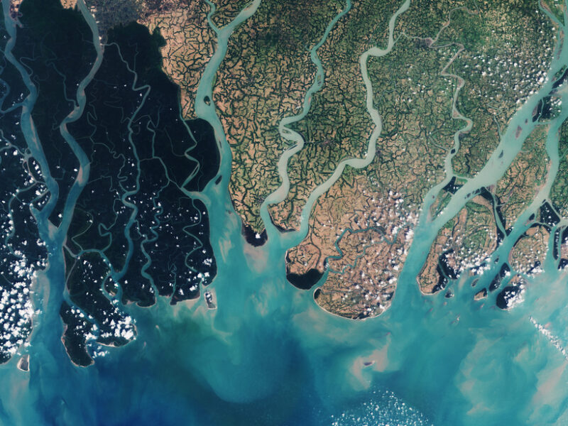
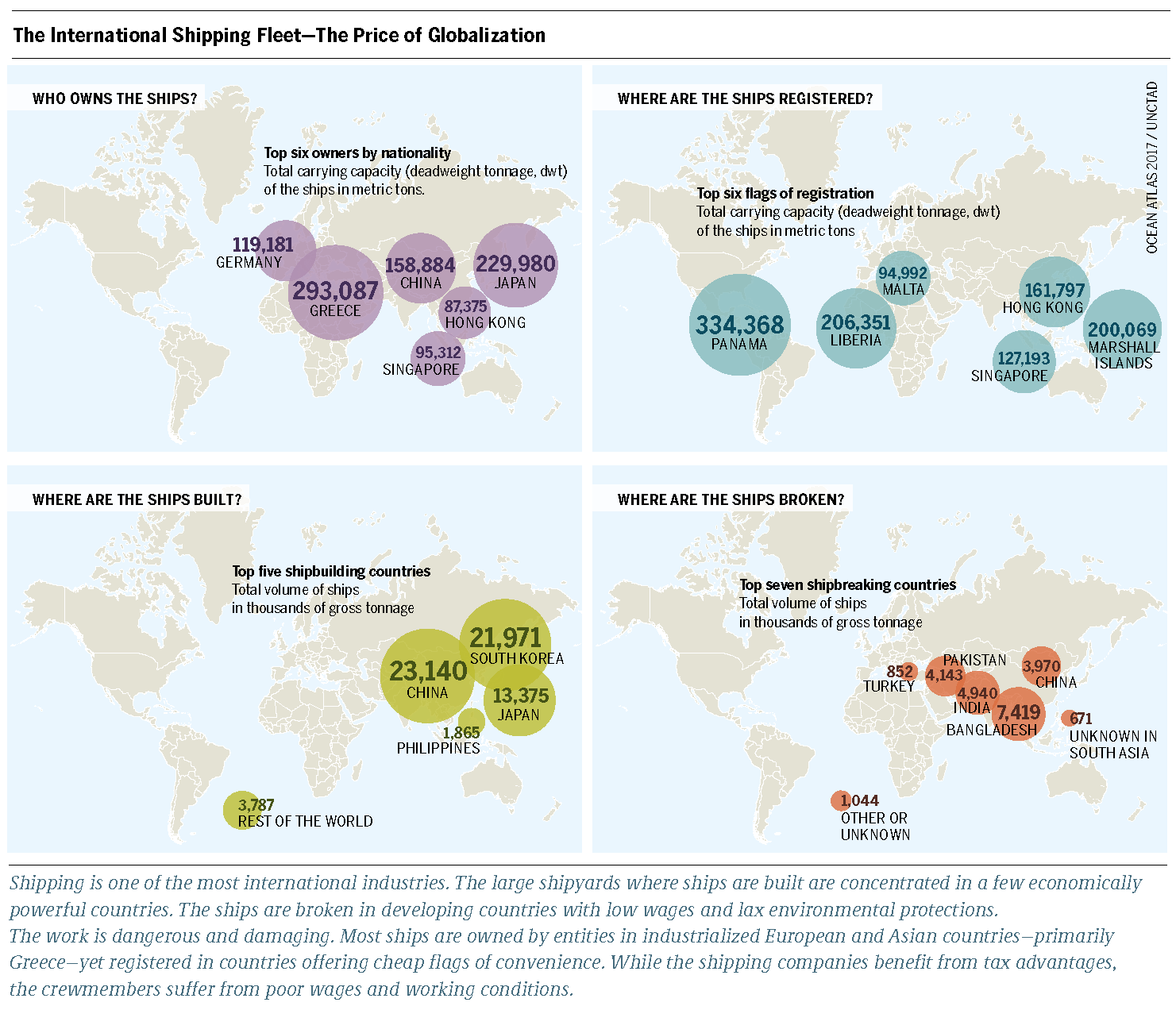
Sentinel-2A natural-color satellite image of the Sundarbans area in the Ganges-Brahmaputra Delta, captured on 18 March 2016.
The erosional forces from the sea and wind along the coast continuously change the landscape, together with the huge amount of silt and other sediments deposited in the countless estuaries, visible in the water.
Satellite images are a key component of coastal monitoring efforts, especially in rapidly changing areas such as this.

From EOS by , G. Le Cozannet, Jérôme Benveniste, , and N. Champollion

The world’s coastal zones, currently home to a large fraction of the world’s population, are under serious threat from coastal erosion, cyclones, storms, and saltwater incursion into estuaries and coastal aquifers.
In the future, scientists expect these hazards to increase because of the combined effects of sea level rise, climate change, human activities, and population increase.

How coastal environments respond to natural and anthropogenic factors depends on the characteristics of the forcing agents, as well as on the properties of the coastal systems that remain poorly known and mostly unsurveyed on a global scale.
To better understand changes affecting coastal zones and to provide useful information to decision-makers, we need to collect and analyze various types of observations with global coverage.

In this context, observations from space represent an important complement to existing in situ observing systems (e.g., regional tide gauge networks).
Here we highlight the benefit of systematic coastal monitoring from space.
Such data combined with in situ observations and databases will be extremely useful to constrain models of coastal change.

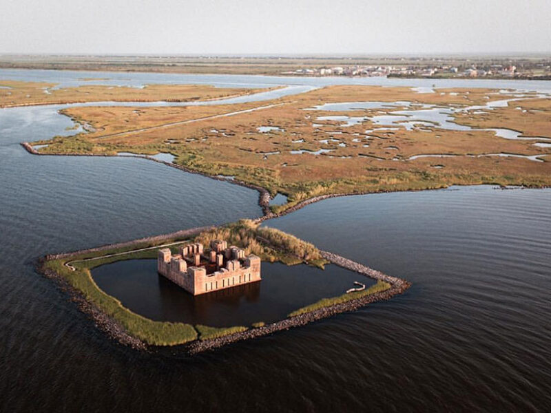
The ruins of Fort Beauregard (also known as Fort Proctor) are partly submerged in Lake Borgne, east of New Orleans, La.
Many coastal areas are sinking even faster than sea level is rising.
Credit: Frank McMains

Issues with Coastal Monitoring

Regional sea level change, winds, waves, currents, extreme events, vertical ground motions, river runoff, sediment supply, land use change and urbanization, policies, and regulations all act as forcing agents on coastal zones.
Satellites have a tremendous potential to observe and characterize these forcing agents, but often, their instruments are not adapted to the special conditions of coastal zones.

For example, coastal residents are particularly concerned about rising sea levels in response to anthropogenic global warming.
High-precision satellite altimetry has considerably improved our understanding of sea level variations at global and regional scales, but that is not the case for coastal areas.
In terms of impacts, what counts at the coast is the sum of global mean rise, superimposed regional variability, small-scale ocean processes, and local vertical land motions.

Satellite altimetry, optimized for the open ocean, performs poorly within 10 kilometers of the coast because land masses contaminate the data.
Recent progress in reprocessing radar waveforms in coastal areas and use of new altimetry techniques (e.g., Ka band altimetry and synthetic aperture radar (SAR) mode) have enabled the satellite community to develop new coastal altimetry data sets.
However, coverage from these products remains uneven in space and time, and efforts are needed to construct a consistent gridded coastal altimetry database with global coverage.

Satellite technology supports the observation and analysis of marine bio-geo-chemical processes at global and regional scale.
This video, produced in 2004, illustrates the activities performed at the Institute for Environment and Sustainability of the Joint Research Centre on the operational use of Earth Observation for marine water quality and climate change investigations.
The MERIS European ocean color sensor was successfully operated onboard the ENVISAT platform from March 1, 2002 till April 8, 2012.
Today European satellite ocean color sensor is called OLCI and operates onboard the Sentinel-3 satellite since mid-2014.

Keeping an Eye on Forcing Agents

To be effective, satellite data must be coupled with in situ measurements; the strengths and limitations of each data source complement each other.
For example, extreme sea levels that result from a variety of oceanic, atmospheric, and terrestrial processes acting on a broad range of timescales are highly correlated with the global mean sea level rise: The higher the global mean rise is, the higher the water elevation is during extreme events [Menéndez and Woodworth, 2010].
Data banks of tide gauge records are valuable sources of information on mean and extreme sea levels, supplementing satellite data.
Version 2 of the Global Extreme Sea Level Analysis (GESLA-2) is the most complete extreme sea level data set assembled to date [Woodworth et al., 2017].
The satellite community has made it a priority to ensure that this activity is maintained and extended in the future.
Although wave models are available at global, regional, and local scales, wave and wind measurements in the coastal zones are still limited.
Altimetry and SAR images can provide such information; however, we need to undertake investigations using existing and upcoming altimeter data sets (in particular using the new SAR mode).
A multisensor approach (altimetry, SAR, and scatterometry) to measuring winds and waves in selected coastal regions could provide much-needed constraints on coastal hydrodynamic and flooding models.

The global mean level of the oceans is one of the most important indicators of climate change.
It incorporates the reactions from severaldifferent components of the climate system.
Precise monitoring of changes in the mean level of the oceans, particularly through the use of altimetry satellites, is vitally important, for understanding not just the climate but also the socioeconomic consequences of any rise in sea level. 
credit CLS

Other forcing agents acting on coastal zones include river runoff, sediment supply, and changes in land use.
Over previous decades, human activities have strongly modified river runoff and sediment delivery to the coastal zone, with great influence on coastal erosion.
Accurate estimates of such quantities are thus crucial.
Satellite altimetry, particularly in ungauged or poorly gauged hydrological basins, now routinely measures the water level on land from which river discharge can be derived.
We can also indirectly estimate river discharge for medium-sized basins (<10,000 square kilometers) from satellite images in the visible and near-infrared spectrum.

The Surface Water and Ocean Topography (SWOT) satellite mission planned for launch in 2021 will improve the characterization of global runoff processes with a 50-meter resolution threshold. Although the capability of remote sensing systems to retrieve land use change is now well established, what’s still missing is an easy-to-use database collecting relevant information with global coverage and long records.

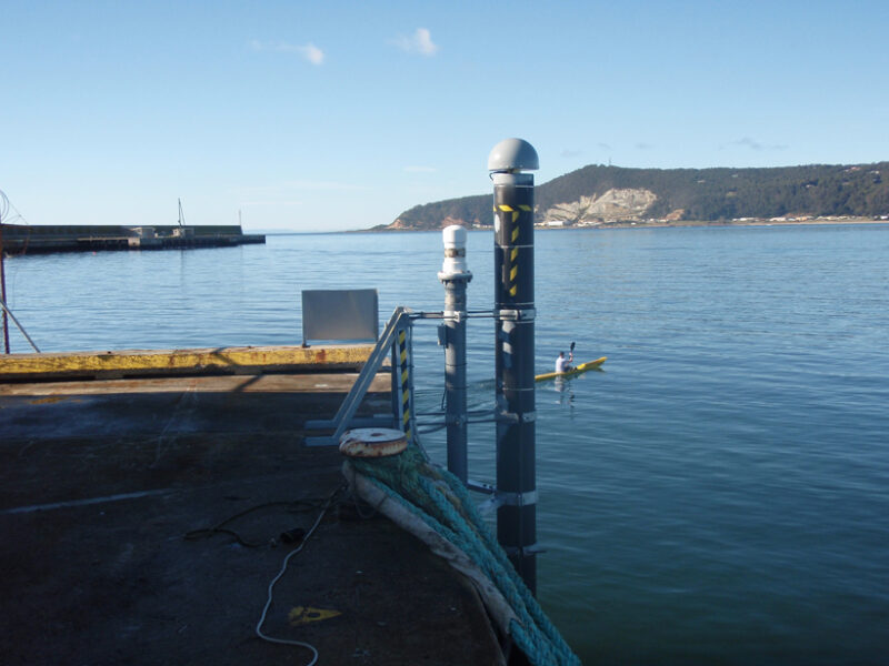
 An acoustic tide gauge monitors the harbor at Burnie on the northern coast of Tasmania, Australia. To its right, a special pillar has a GNSS receiver on top.
Credit: © Commonwealth of Australia (Geoscience Australia) 2016.

Net subsidence and the resilience of many of the world’s significant deltas (home to millions of people, infrastructure, and significant food supply) are the summed response to sediment supply, land subsidence in response to water and hydrocarbon extraction, and land use change.
Techniques like Global Navigation Satellite Systems (GNSS) and interferometric synthetic aperture radar (InSAR) provide invaluable information on land motions at local scales [Allison et al., 2016], but many coastal zones are not equipped with GNSS receivers, and systematic monitoring of land motions by InSAR is still missing in many vulnerable areas such as the low-lying coasts of Pacific islands and subsiding cities of southeastern Asia.
Thus, we need to equip the most vulnerable coastal sites with precise positioning equipment to measure long-term vertical land motions.

CNES video,
outlining how Jason-3 satellite data is used to monitor coastal erosion and predict flooding.

Keeping an Eye on Coastal Evolution

Sediment supply and transport processes drive changes occurring along shorelines and in nearshore coastal zones as well as in river estuaries.
These changes are still poorly quantified in most coastal areas, and coastal observatories developed to track them using in situ and airborne data remain limited.

Here again, space data offer an opportunity to gather additional observations with a global perspective.
Currently, most space-based initiatives are based on a visual processing of high-resolution optical data (0.5- to 1-meter resolution) from imaging satellites.
Errors in georectification (aligning satellite images with maps) and on shoreline indicators lead to an effective precision of 1–5 meters in the shoreline position.

However, because we currently lack automatic techniques for processing these data, no global satellite-based database of shoreline position changes exists.
Automatic analysis of optical images, the use of high-resolution synthetic aperture radar images in cloudy tropical areas, and accurate estimates of shoreline indicators thus represent high-priority objectives for science fields related to coasts.

Global to regional data sets based on ocean color sensors allow us to quantify the dynamics of suspended sediment, which has been related to shoreline changes with some success close to dynamic estuaries such as the Amazon and Mekong estuaries [e.g., Loisel et al., 2014].
However, we need further methodological developments that allow repeated data acquisitions in highly dynamic areas (e.g., estuaries, sandy inlets, and sandy beaches) to improve our understanding of coastal evolution in other types of coastal environments.
For example, suspended sediments are visible in the above satellite image of the Ganges-Brahmaputra Delta.

High-resolution digital elevation models and coastal bathymetric data are other examples of critical data sets needed for a number of applications in coastal zones, including accurate modeling of flooding during storm surges and quantification of coastal morphological changes due to sedimentary processes or human interventions.
A high-precision (~20 centimeters) and high-resolution (~1 to 10 meters) database of continuous marine-land topography and bathymetry would be particularly useful to represent detailed submersion patterns while being consistent with uncertainties of extreme sea level values.

Lidar techniques have enabled important progress, but they still require postprocessing to remove features like trees or vehicles from the raw data.
Repeated bathymetric surveys with wide coverage would be useful to understand nearshore coastal processes.
We expect progress from new techniques such as satellite and drone-acquired high-resolution imagery.
Nearshore bathymetry, shoreline changes, and high-resolution topography are definitely observational priorities, especially along densely populated coastlines.

Putting It All Together

If we are to make progress on understanding the magnitude and causes of changes in the coastal zone on a global basis, we must make considerable investments in space-based as well as in situ observation systems.
Modeling and synthesis activities must accompany the measurements, so that the research can provide insight into the future change of coastal areas.

Finally, access to global coastal data sets is still too limited.
International efforts such as the World Climate Research Programme should consider establishing a data repository gathering all needed coastal observations, whether collected locally or through satellite remote sensing.

From Miami to Shanghai : 3C of warming will leave world cities below sea level

$
0
0
How Shanghai would look with a rise of just 2C: the UN warned this week of a potential 3C scenario.
Photograph: Nickolay Lamm/Courtesy Climate Central

From The Guardian by Jonathan Watts

An elevated level of climate change would lock in irreversible sea-level rises affecting hundreds of millions of people, Guardian data analysis shows

Hundreds of millions of urban dwellers around the world face their cities being inundated by rising seawaters if latest UN warnings that the world is on course for 3C of global warming come true, according to a Guardian data analysis.

Famous beaches, commercial districts and swaths of farmland will be threatened at this elevated level of climate change, which the UN warned this week is a very real prospect unless nations reduce their carbon emissions.


which was approved by the White House,
was compiled by US government scientists.

Data from the Climate Central group of scientists analysed by Guardian journalists shows that 3C of global warming would ultimately lock in irreversible sea-level rises of perhaps two metres.
Cities from Shanghai to Alexandria, and Rio to Osaka are among the worst affected.
Miami would be inundated - as would the entire bottom third of the US state of Florida.

The Guardian has found, however, that local preparations for a 3C world are as patchy as international efforts to prevent it from happening.
At six of the coastal regions most likely to be affected, government planners are only slowly coming to grips with the enormity of the task ahead - and in some cases have done nothing.

This comes ahead of the latest round of climate talks in Bonn next week, when negotiators will work on ways to monitor, fund and ratchet up national commitments to cut CO2 so that temperatures can rise on a safer path of between 1.5 and 2C, which is the goal of the Paris agreement reached in 2015.

The momentum for change is currently too slow, according to the UN Environment Programme.
In its annual emissions gap report, released on Tuesday, the international body said government commitments were only a third of what was needed.
Non-state actors such as cities, companies and citizens can only partly fill this void, which leaves warming on course to rise to 3C or beyond by the end of this century, the report said.

The UN’s environment chief, Erik Solheim, said progress in the year since the Paris agreement entered into force has been inadequate.
“We still find ourselves in a situation where we are not doing nearly enough to save hundreds of millions of people from a miserable future,” he said.

 South Beach, Miami, would be mostly underwater.
Photograph: Nickolay Lamm/Courtesy Climate Central

Nature’s ability to help may also be diminishing.
On Monday, the World Meteorological Organisation said concentrations of carbon dioxide in the atmosphere rose last year at a record speed to reach 403.3 parts per million - a level not seen since the Pliocene era three to five million years ago.

A 3C rise would lead to longer droughts, fiercer hurricanes and lock in sea-level rises that would redraw many coastlines.
Depending on the speed at which icecaps and glaciers melt, this could take decades or more than a century.
Colin Summerhayes of the Scott Polar Research Institute in Cambridge said three-degrees of warming would melt polar and glacier ice much further and faster than currently expected, potentially raising sea levels by two metres by 2100.

At least 275 million city dwellers live in vulnerable areas, the majority of them in Asian coastal megacities and industrial hubs such as Shanghai, Shenzhen, Bangkok and Tokyo.

Japan’s second biggest city, Osaka, is projected to lose its business and entertainments districts of Umeda and Namba unless global emissions are forced down or flood defences are built up.
Officials are reluctantly accepting they must now put more effort into the latter.

“In the past our response was focused on reducing the causes of global warming, but given that climate change is inevitable, according to the Intergovernmental Panel on Climate Change (IPCC), we are now discussing how to respond to the natural disasters that will follow,” said Toshikazu Nakaaki of the Osaka municipal government’s environment bureau.

In Miami - which would be almost entirely below sea level even at 2C warming - the sense of urgency is evident at city hall, where commissioners are asking voters to approve a “Miami Forever” bond in the November ballot that includes $192m for upgrading pump stations, expanding drainage systems, elevating roads and building dykes.

Elsewhere, there is less money for adaptation and a weaker sense of urgency.
In Rio de Janeiro, a 3C rise would flood famous beaches such as Copacabana, the waterfront domestic airport, and many of the sites for last year’s Olympics.
But the cash-strapped city has been slow to prepare.
A report compiled for Brazil’s presidency found “situations in which climate changes are not considered within the scope of planning”.

Image of Candelária Church in Rio, Brazil, with a 4°C temperature rise scenario.

In Egypt, even a 0.5m sea-level rise is predicted to submerge beaches in Alexandria and displace 8 million people on the Nile Delta unless protective measures are taken, according to the IPCC.
But local activists say the authorities see it as a distant problem.
“As far as I’m concerned, this issue isn’t on the list of government priorities,” said Ahmed Hassan, of the Save Alexandria Initiative, a group that works to raise awareness of the effects of climate change on the city.

The impacts will also be felt on the economy and food production.
Among the most vulnerable areas in the UK is Lincolnshire, where swaths of agricultural land are likely to be lost to the sea.

“We’re conscious that climate change is happening and perhaps faster than expected so we are trying to mitigate and adapt to protect people and property.
We can’t stop it, but we can reduce the risk.” said Alison Baptiste, director of strategy and investment at the UK Environment Agency.
She said the measures in place should protect most communities in the near and medium term, but 50 years from now the situation will become more challenging.
“If climate change projections are accurate, we’re going to have to make some difficult decisions.”

Links :


Meet the British lawyer who's swimming the Antarctic Ocean in his Speedos to save our seas

$
0
0
Lewis Pugh, pushing the limits of the human body
Credit : Kelvin Trautman

From The Telegraph by Annabel Fenwick Elliott

The 37-year-old British lawyer Lewis Pugh will dive into the Antarctic Ocean today clad in nothing but his Speedos, and front-crawl his way across a cove in what will be his most dangerous stunt yet.

Is the man mad?
No, he's on a noble mission.
Pugh - the only person to complete a long-distance swim in every ocean of the world - has been ploughing his way through freezing seas for 30 years now, all in a bid to protect and conserve them.

His one kilometre (0.6 mile) swim will take him across King Edward Cove in South Georgia, past the Grytviken Whaling Station and the gravesite where explorer Sir Ernest Shackleton was laid to rest.

Emerging from the Arctic following a prior record-breaking swim

Pugh, a maritime lawyer, spoke to Telegraph Travel from Antarctica about how he prepares his body to withstand temperatures that would kill an ordinary human, why today's swim is particularly dangerous, and what all this has to with marine conservation.

The training

"Without rehearsing, you'd drown pretty quickly in 0°C water," he explains.
"It's taken at least six months of very hard training to get to this point, and I only train in the sea - usually in temperatures of around 12°C."

Pugh has spent the last week acclimatising in progressively colder temperatures, much like a mountaineer tackles high altitudes.
Interestingly, scientists have found that his body temperature rises significantly just before he dives in, up to 38.2°C in the past.
South African sports medicine professor Tim Noakes noted this first, and coined it "anticipatory thermogenesis" - a Pavlovian response due to his years of cold water swimming
"I call it fear," jokes Pugh.
"But we aren't certain of the true reason."

 Lewis describes these swims as "excruciating", unsurprisingly

Taking the leap

"I always dive, and never dip my toe in first," Pugh says.
"As soon as I hit the water, my capillaries constrict to defend the warmth in my body and the blood rushes to my core to protect my vital organs."

From here, it's an uphill battle against his body's natural panic response.
"First, I need to calm down and control my breathing," he says.
The pain is excruciating.
I’ll think of dozens of reasons to get out, so I try to focus on just one thing to keep on going."


UN Environment Patron of the Oceans and endurance swimmer Lewis Pugh has traveled to Antarctica to raise awareness about the crucial need to protect its ecosystems.
"Ordinary won't change the World".

Pugh can swim for around 20 minutes before his system packs up.
"After that, my arm stroke slows considerably," he explains.
"As my core temperature drops, my hands can no longer grip the water, my coordination starts going and I turn bright red as the blood rushes to the surface of my skin, radiating heat."

 The race to warm up
Credit : Kelvin Trautman

With this particular swim, Pugh will be in the domain of some formidable ocean predators; elephant seals, Antarctic fur seals, leopard seals and killer whales.
"None of these animals will have ever seen a human swimming," Pugh says.
"The waters are full of them, and the last thing I want is for one of them to take a bite out of me."
As soon as he's out of the water, Pugh's team rushes him to a hot shower where it takes at least 50 minutes for his core temperature to normalise.


Why the Speedos?

Surely it would make more sense to execute these swims in protective gear, a wetsuit at the very least. But that, apparently, would be too easy.
"I ask world leaders to do everything they can to protect our oceans," Pugh remarks.
"Sometimes the steps they need to take are difficult and unpopular. If I’m asking them to be courageous, I must also be. Swimming in a wetsuit would not send the right message."

All to keep the fishing boats away

As fish stocks plummet around the world, industrial fishing fleets are seeking new seas to exploit, according to Pugh, who warns: "It's only a matter of time before they set their sights on the South Sandwich Islands. This pristine ocean wilderness is under imminent threat."

 He's the only human to have completed a long-distance swim in all of the world's seven oceans
Credit : Kelvin Trautman

He hopes his latest swim will draw attention to his cause.
"I am urging the UK government to fully protect this unique ecosystem, starting with the creation of a 'No Take Zone' around the South Sandwich Islands.
If we don’t protect them now, we risk losing them forever."

Last year Pugh played a pivotal role in creating the largest protected area in the world, in the Ross Sea off Antarctica.
Between his media-grabbing swims, he shuttled between the US and Russia to help negotiate the final agreement.

In 2007, he was the first person to undertake a long-distance swim across the North Pole, which he did to highlight the melting of the Arctic sea ice.
And in 2013 the United Nations appointed him as the first "UN Patron of the Oceans".

Lewis is pushing for this Antarctic region to be protected

Why is this slice of ocean so important?

South Georgia and the neighbouring South Sandwich Islands - all British Overseas Territories - are considered to be among the world's most important spots in terms of biodiversity.

They’re home to an astonishing array of marine wildlife; 95 per cent of the total Antarctic fur seal population, more than 50 per cent of southern elephant seals, and nearly 20 per cent of the world's penguins.
They are also a haven for sea birds and whale species, among them the endangered blue whale.

Climate change has been cited as a major threat to this region, as well as overfishing - all issues taking the front seat in BBC’s ground-breaking Blue Planet II series.
Britain has taken a global lead in marine conservation with its "Blue Belt" policy, planning to conserve nearly four million square kilometres of natural ocean habitat by 2020.

Pugh wants to make sure the South Sandwich Islands falls within it, and he’s got the Speedos to prove it.

Links :

Lower emissions on the high seas

$
0
0
Polluting vessels use the dirtiest fuels with emissions from one container ship equivalent to 50 Million carsVoluntary efforts to tackle carbon pollution from the shipping industry have failed.

From Nature

In Herman Melville’s novel Moby-Dick, seafaring is the occupation of adventure-lovers.
But since the maritime classic was published in 1851, the act of ‘sailing about a little’ has become a huge commercial undertaking.
Today, a massive fleet of cargo ships transports 90% of global consumer goods.
Shipping is efficient — but comes with an environmental cost that has not been adequately accounted for.

  courtesy meereatlas.org

Worldwide, there are about half a million ships in operation, together producing almost one billion tonnes of carbon dioxide each year.
That’s between 2% and 3% of the global total, and more CO2 than Germany emits annually.
But unlike greenhouse-gas emissions from Germany and other nations, shipping emissions are not subject to the reduction pledges made by individual nations under the Paris climate agreement.
(The Paris deal does, however, include shipping emissions in its global carbon-budget calculations.)

 courtesy meereatlas.org

After years of inaction, the great white whale of greenhouse-gas pollution is now in the cross hairs of the International Maritime Organization (IMO), the specialized United Nations agency that sets safety and environmental standards for the global shipping industry.
The IMO is under pressure from campaigners and representatives of other, regulated sectors to agree a global cap on shipping emissions.


Sentinel's new air pollution map shows spooky correlation with shipping lanes.

Following sharp increases in the early 2000s, the sector’s emissions have remained more or less stable since the global financial crisis of 2008.
But that is unlikely to continue.
The current overcapacity in the maritime cargo market means that ship traffic (and emissions) can increase quickly to meet demand.
Moreover, the shipping industry at large — including the cruise sector — has potential to grow, and rapidly.

 Share of CO2 emissions by ship class (left) and flag state (right), 2013–2015

The IMO has a specialist greenhouse-gas working group that is grappling with the idea of a cap.
But its latest meeting, held last week in London, closed without declaring much progress.
Overall, the IMO is committed to tightening environmental standards for new ships.
Yet its technology-oriented strategy — including an Energy Efficiency Design Index that requires the engines of vessels to burn less fuel — is unlikely to be enough.
Cleaning up the industry will require adequate market instruments and economic incentives to encourage owners and operators of both ships and ports to adopt climate-friendly practices, such as enforcing lower speeds.

 Mandatory limits on emissions of sulfur oxides (SOx) and nitrogen oxides (NOx),
both globally and within designated sea areas known as Emission Control Areas (ECA)

Owing to the peculiarities of this volatile business, the routes, speed and fuel consumption of tens of thousands of container ships are hard to monitor and verify.
An emissions-trading system, for example, would be difficult to implement and even harder to manage.
The IMO agreed last year to set up a global CO2 data-collection system that will yield welcome knowledge, as will improvements in tracking the positions and movements of ships from space.
But a tax by national governments on fossil fuels used by ships — incurred at refinery level — might be a more effective economic mechanism.

 Shipping CO2 emissions compared to global CO2 emissions

Voluntary efforts alone will not do.
The industry has set up a series of half-hearted and overlapping eco-ratings schemes since the 2000s.
But an analysis published online on 16 October shows that these have had no notable effect on the environmental performance of ships (R.T. Poulsen et al. Mar. Policy 87, 94–103; 2018).
Whereas eco-ratings can steer companies to make more-efficient refrigerators and washing machines in line with the preferences of consumers and regulators, maritime transport is different.
The pressure of end-users is too distant to influence ship owners and operators.
And price remains the dominant factor for builders and buyers of cargo ships.

As a global business, shipping must be tackled by global regulations, and not through a patchwork of voluntary efforts and regional laws.
It is true that some regional efforts, such as the European Union’s scheme to monitor, report and verify CO2 emissions from large ships using its ports, might be a step towards global regulations.

 EMSA ship emissions monitoring via drone sniffers EMSA ship emission monitoring.

The IMO has already shown that it can tackle other environmental issues.
Measures it introduced in the wake of the Exxon Valdez oil spill in 1989 ensure that oil tankers are now much safer.
An inter­national convention for ballast-water management, which aims to control the spread of harmful invasive species, came into force in September after years of preparation (although it does not address biofouling on ships’ hulls, which is potentially more harmful to local ecology).
The IMO has also agreed measures to encourage environmentally responsible ship recycling and minimize uncontrolled shipbreaking, much of which occurs on South Asian beaches.
However, this 2009 Hong Kong convention is still not implemented and is awaiting ratification by most member parties.

 The CMA CGM Group said Tuesday it will equip its nine future ships of 22,000 TEUs delivered in 2020 with engines using liquefied natural gas.
CMA CGM becomes the first shipping company in the world to equip giant container ships with this type of motorization, pursuing its commitment to protect the environment and aid in ocean conservation. 

When it comes to the impact on climate, there is no excuse for delay.
Emissions from shipping largely escape the public scrutiny and criticism attracted by those from aviation.
Parties to the IMO should step up and hasten the implementation of the necessary standards.

Links :

Satellites guide ships in icy waters through the Cloud

$
0
0

The US Coast Guard Cutter Maple being escorted by Canadian Coast Guard Ship Terry Fox.

From ESA

In late August, the 60 m-long US Coast Guard Cutter Maple completed its navigation through the Arctic’s ice-ridden Northwest Passage.
While this was not the first time ships had taken this route, it was the first time that the International Ice Patrol had provided iceberg information based exclusively on satellite imagery.

Established in 1914 in response to the sinking of the Titanic, the US Coast Guard International Ice Patrol (IIP) monitors iceberg danger in the North Atlantic Ocean for shipping safety.

When the Maple departed from Alaska in mid-July en route through the Arctic to Maryland, USA, the IIP was on guard to assist the crew to navigate through the notoriously icy waters.

The region through which the ship Maple transited 14–18 August 2017, with approximate ship locations identified in yellow on each day.
The map has been overlaid with images from the Sentinel-1 radar satellite mission.


The IIP used data from the Copernicus Sentinel-1 satellite mission, among others, to create charts showing the risk of encountering icebergs after exiting from the Northwest Passage and during transit through the Baffin Bay, Davis Strait and Labrador Sea.
Sentinel-1 is equipped with radar that can detect icebergs through cloud cover, a capability particularly beneficial in the IIP’s operating area.
Sentinel-1 can also distinguish between the thinner, more navigable first-year ice and the hazardous, much thicker multiyear ice to help assure safe year-round navigation in ice-covered Arctic and sub-Arctic zones.

These radar images are particularly suited to generating high-resolution ice charts, monitoring icebergs and forecasting ice conditions.

 Using ESA’s online Polar Thematic Exploitation Platform (Polar TEP), the International Ice Patrol accessed satellite data to detect icebergs and analyse their densities and trajectories.

Scientists at the IIP used iceberg detection software available on ESA’s online Polar Thematic Exploitation Platform (Polar TEP) to access satellite data to detect icebergs and analyse their densities and trajectories.

“This experience using the Polar TEP cloud-based technology opens the door for future evaluations of a more robust version of the iceberg detection and iceberg trajectory processors,” said Michael Hicks, Chief Scientist of the International Ice Patrol.
“Cloud-based technology such as that used by Polar TEP is expected to be an important tool for handling the ever-growing amount of data coming from space.”


Polar TEP provides polar researchers
with access to computing resources, data and software tools for polar research.

Polar TEP is one of six Thematic Exploitation Platforms developed by ESA to serve data user communities.
These cloud-based platforms provide an online environment to access information, processing tools and computing resources for collaboration.
TEPs allow knowledge to be extracted from large environmental datasets produced through Europe's Copernicus programme and other Earth observation satellites.


Image of the week : clouds bring beauty for Volvo Ocean Race fleet


Blue Planet II : in the deep with a submarine

$
0
0
Sharks Attack Submarine

Never before have humans journeyed to the Antarctic deep sea.
Scientist Dr Jon Copley reveals what it’s like to travel 1000m beneath the ice 
Links :

Ghost ships IRL: How autonomous cargo boats could disrupt the massive shipping industry

$
0
0
Autonomous ships are almost here.
What is going to be their impact in shipping ?

From CBinsight

Unmanned marine vehicles will use sensors & AI to crisscross the world’s oceans without a crew – potentially lowering costs & improving safety for the $334B shipping sector.

Just as driverless cars and trucks are bringing huge changes to the auto industry, and drones are disrupting everything from emergency response to conservation, autonomous ships are becoming the next major transportation innovation.

A number of startups and governments are piloting “unmanned marine vehicles” or crewless cargo boats, with the potential to disrupt the $334B shipping industry.


Rolls-Royce already demonstrated the world’s first remotely operated commercial vessel earlier this year, and the US military is testing an experimental, autonomous warship called the Sea Hunter.

Fully autonomous ships aren’t yet allowed in international waters.
But with more and more companies (and governments) developing driverless vessels, the UN is considering policy changes that would allow unmanned boats to crisscross oceans, signaling a major sea-change to the global rules governing transport.

That means “crewless cruising” by cargo vessels could take over the shipping industry sooner than you think.
Already, there is a “ghost ship” that is expected to be ferrying cargo for commercial use as soon as 2020.

Rendering of an autodocking system for a self-driving ship
credit : Rolls-Royce

The benefits of crewless cargo ships could be significant.
A boat with no crew has no need for sleeping quarters, kitchens, or bathrooms, and can devote more of that space to products for transport; crewless shipping boats also don’t incur the costs associated with keeping people at sea for long stretches.

Autonomous ships will not only enhance global shipping capacity (lowering transport costs and fuel consumption in the process), they can also potentially lead to safer seas: Human error accounts for over 60% of shipping accidents, according to EU data.

Using vast networks of connected data sensors (and many of the same technological systems found in driverless cars and aerial drones), autonomous boats will share data and communicate amongst one another to navigate the high seas unmanned.

These crewless vessels will either be operated remotely, like drones (via human control and technical monitoring on land) or self-drive autonomously, like driverless cars (via programmed mapping and artificial intelligence, without any human intervention).

Boats of both kind are right around the corner.
“This is happening. It’s not if, it’s when. The technologies needed to make remote and autonomous ships a reality exist… We will see a remote controlled ship in commercial use by the end of the decade.”
Oskar Levander, Rolls-Royce’s VP of Marine Innovation, made the above comments when the company announced its “Advanced Autonomous Waterborne Applications Initiative” (AAWA) last year.

Rolls-Royce’s autonomous-vessel operation is among the most advanced in the space.
Rolls-Royce has worked extensively in the shipping sector for decades, but launched the AAWA project as part of a broad vision to make better use of “ship intelligence” – aka the data from ships’ vast networks of systems and sensors.

As part of that vision, Rolls-Royce intends to use a land-based control center (staffed with a small crew of 7 to 14 people) to monitor and control a fleet of remote-controlled and autonomous seafaring vessels around the world.
It is also working with Google to develop more robust “intelligent awareness systems” for both existing vessels and the autonomous ships of the future.

The company has already taken its efforts well beyond the virtual realm.

Rolls-Royce did a ghost-ship demo in June 2017 in which an 28-meter vessel berthed itself, undocked, turned 360°, and piloted itself to back to the starting point before docking again — all via remote control, on land.


As part of its AAWA project, the British automaker has also studied the safety, cybersecurity, and liability issues facing autonomous ships.

While Rolls-Royce is a leader in the space, other private companies are also moving towards rapid commercialization of automous shipping vessels:
Several of Japan’s largest shipping outfits (including Mitsui OSK Lines, Nippon Yusen, and others) have reportedly joined forces to develop a fleet of 250 remote-controlled cargo ships that could be launched by 2025.
The Japanese government is supporting their initiative, backing research into data transmission efforts and standards around autonomous vessels.

Kongsberg, a Norwegian technology company, is developing the YARA Birkeland – which will be the world’s first fully electric and autonomous container ship.
To comply with international maritime law, the YARA Birkeland will operate close to the Norweigan shore when it begins sailing in 2020, ferrying fertilizers between three Norwegian ports.
While not focused on shipping, some startups are creating driverless vessels that also stay close to the shore: RanMarine operates a Roomba-like unmanned marine vehicle used to collect waste in ports and harbors; Orobotix makes sub-sea drones to help operators automate underwater inspection tasks.


Regulatory hurdles

While much activity is happening on the development side, autonomous cargo ships still won’t have a major impact on the shipping industry until they can cross international waters, since the maritime shipping industry is largely focused on transporting goods between distant countries.
Given this constraint, the UN is beginning to have discussions on the topic:
The UN’s International Maritime Organisation (IMO) – which regulates shipping – began discussions in June 2017 that could allow unmanned ships to operate across oceans; IMO will continue to consider changing the “International Convention for the Safety of Life at Sea” (SOLAS) to allow ships with no captain or crew to travel between countries.
Sovereign entities will likely ensure the rules of the sea are rewritten sooner rather than later: The European Union has put $4B into its MUNIN project (short for Maritime Unmanned Navigation through Intelligence in Networks); and DARPA is currently testing its autonomous-submarine the Sea Hunter (which it developed in response to “advancements” China and Russia are making in the space, according to officials).

The 132-foot Sea Hunter is powered by diesel engines and is designed to operate autonomously, for months at a time, without a crew or any human control.
Watch the demonstrations of the Sea Hunter below.


DARPA’s Anti-Submarine Warfare (ASW) Continuous Trail Unmanned Vessel (ACTUV) program has designed, developed and constructed an entirely new class of ocean-going vessel—one intended to traverse thousands of kilometers over the open seas for months at a time, all without a single crew member aboard.
The ACTUV technology demonstration vessel was recently transferred to water at its construction site in Portland, Ore., and conducted speed tests in which it reached a top speed of 27 knots (31 mph/50 kph).

Unmanned marine vehicles will use sensors & AI to crisscross the world’s oceans without a crew – potentially lowering costs & improving safety for the $334B shipping sector.

Do the benefits outweigh the risks?

Advocates for autonomous cargo boats tout a number of potential benefits to these vessels.
  • Safety: Insurance data shows that people cause the majority of ship accidents and resulting damages; in 2016, at least 75% of insured marine losses arose from human error, according to the most recent AGCS Global Claims Review.
  • Costs: Paying a crew can account for almost half of a cargo ship’s expenses. And with no requirement for manned spaces and accommodation, driverless vessels are expected to be cheaper to build with lower operating costs.
  • Energy: Most vessels in development are either highly energy-efficient or entirely electric, which is good for the environment and potentially cheaper to operate. (The YARA Birkeland, for example, touts zero emissions.)
  • Capacity: Physical spaces formerly reserved for people are utilized to increase cargo load, potentially making import-export processes faster and more efficient around the world.
  • Piracy Risk: Uncrewed ships can be built so that they are difficult for pirates to board. Even if pirates got aboard, access to controls could be disabled remotely, and authorities could be rapidly notified (via data) to intervene. And with no crew to hold hostage for ransom, the incentive for piracy is fairly low anyway.
  • Data Use: Enhanced ship intelligence cultivated by data-smart, sensor-equipped cargo ships will be used to map more efficient shipping routes, inform fuel-use modeling, and better understand geological activities and climate fluctuations.
But while the benefits may seem obvious, there are significant concerns around just how much money these ships could save, and whether “roboships” should really be considered safer than existing vessels.

Such concerns play into the regulatory considerations: The existing International Regulations for Preventing Collisions at Sea, for example, were written with conventional crewed ships in mind, and provide no absolute “right of way” for vessels.
Rule 2, in particular, requires real-time human judgment to avoid immediate danger.

Given the liabilities at stake, modifying long-held marine standards — and removing the role of humans from them entirely — is no small concern to maritime insurers.

Consider the safety issue: Even though 62% of shipping accidents occur thanks to human error, an estimated 1.65 million skilled workers labor on international merchant ships today.
And as Rule 2 shows, their roles aboard those ships are not seen as insignificant.

Many believe that removing experienced crew from ships means that any accidents that do occur could be far more severe (since personnel would not be on-hand to mitigate ship damage or intervene in any resulting environmental disasters).

Ultimately, this creates a number of questions for maritime insurers.
And how insurers support or resist the commercialization of these vessels, and potentially price policies, will also have an impact on how the industry develops.

 Concept autonomous ship guidance center

Will data be the real advantage?

A recent study by researchers at the Fraunhofer Center for Maritime Logistics and Services weighed the overall potential for driver-less ships to reap returns: In an exploratory cost-comparison between an autonomous vessel and a conventional bulk carrier, researchers found that there are indeed savings to be made – mainly around crew pay, accommodations, and utilities.

But new costs factor into play, too.
To deploy driver-less cargo ships, companies will need to equip their fleets with advanced sensors and control systems.
Recruiting a land-based workforce (and expensive new operations centers) will also absorb resources and offset savings.

The expenses add up: Even factoring in the much-improved fuel efficiency of greener autonomous boats, the Fraunhofer Center study found that an unmanned bulk cargo carrier may be able to reduce the cost of carrying freight by only around 3.4%.

 The YARA Birkeland will be the world’s first fully electric & autonomous container ship by 2020. credit: Kongsberg

But for any of the world’s massive global freight or logistics companies (such as UPS, DHL, or Amazon) a 3.4% reduction in costs represents millions in recouped revenue, which may be incentive enough to embrace the technology.

And even though there are over 1 million ship-bound jobs at stake, at least a portion of the job losses will be offset by job growth in new areas.

Just as driverless cars will disrupt industries well beyond auto – ranging from parking garages to public transit– driverless ships will likewise upend dozens of shipping-related sectors and standards, leading to new work at ports and manufacturing centers.


And the tech may create jobs in other areas, too, thanks to data.
With Rolls-Royce and Google, for example, already collaborating to use marine data sets in various AI and machine learning models, there’s no limit to how marine intelligence could reshape the transportation sector at large.
“Autonomous shipping is the future of the maritime industry,” says Mikael Makinen, President of Rolls-Royce Marine.
“As disruptive as the smartphone, the smart ship will revolutionize the landscape of ship design and operations.”
Links :

Scientists warn of 'giant leap backward' at climate talks

$
0
0

Hard to ignore 15000 scientists from 184 nations
who issue second warning to humanity on catastrophic climate change.

From NPR

Carbon dioxide emissions are set to rise this year after a three-year pause, scientists said at UN climate talks Monday, warning that "time is running out", even as White House officials used the occasion to champion the fossil fuels that drive global warming.

CO2 emissions, flat since 2014, were forecast to rise two percent in 2017, dashing hopes they had peaked, scientists reported at 12-day negotiations in the German city of Bonn ending Friday.
"The news that emissions are rising after a three-year hiatus is a giant leap backward for humankind," said Amy Luers, a climate policy advisor to Barack Obama and executive director of Future Earth, which co-sponsored the research.
Global CO2 emissions for 2017 were estimated at a record 41 billion tonnes.
"Time is running out on our ability to keep warming below two degrees Celsius (3.6 degrees Fahrenheit), let alone 1.5 C," said lead author Corinne Le Quere, director of the Tyndall Centre for Climate Change Research at the University of East Anglia.

In 1992, scientists warned that humans had to change or the Earth would become unlivable.
What's changed 25 years later?

The 196-nation Paris Agreement, adopted in 2015, calls for capping global warming at 2 C below pre-industrial levels.
With the planet out of kilter after only one degree of warming—enough to amplify deadly heatwaves, droughts, and superstorms—the treaty also vows to explore the feasibility of holding the line at 1.5 C.
"As each year ticks by, the chances of avoiding 2 C of warming continue to diminish," said co-author Glen Peters, research director at Center for International Climate Research in Oslo, Norway.
"Given that 2 C is extremely unlikely based on current progress, then 1.5 C is a distant dream," he told AFP.

The study identified China as the single largest cause of resurgent fossil fuel emissions in 2017, with the country's coal, oil and natural gas use up three, five and 12 percent, respectively.
Earth is overheating due to the burning of oil, gas and especially coal to power the global economy.

Sea ice as viewed from NASA's research aircraft in the Antarctic Peninsula region this month.Scientists warn that Earth is heading towards a dangerous 'tipping point' which could result in the disintegration of Antarctic ice sheets

'You're liars!'

That did not discourage US officials from the administration of President Donald Trump from making a case at the UN negotiations for "The Role of Cleaner and More Efficient Fossil Fuels and Nuclear Power in Climate Mitigation."
"Without a question, fossil fuels will continue to be used," George David Banks, a special energy and environment assistant to the US president told a standing-room only audience, citing projections from the International Energy Agency (IEA).
Faced with this reality, "we would argue that it's in the global interest to make sure that when fossil fuels are used, that it's as clean and efficient as possible."

Flanked by Francis Brooke from the office of Vice President Mike Pence, and senior representatives of American energy companies, Banks addressed a packed room where protesters shouted "you're liars!" and "there's no clean coal!".
Former New York mayor Michael Bloomberg, UN special envoy for cities and climate change, tweeted: "Promoting coal at a climate summit is like promoting tobacco at a cancer summit."
The US is the only country in the world that has opted to remain outside the Paris Agreement.

More than 15,000 scientists meanwhile warned that carbon emissions, human population growth, and consumption-driven lifestyles were poisoning the planet and depleting its resources.
"We are jeopardising our future," they wrote in a comment entitled "World Scientists' Warning to Humanity: A Second Notice," echoing a similar open letter from 1992.
It is "especially troubling" that the world continues on a path toward "potentially catastrophic climate change due to rising greenhouse gases from burning fossil fuels," they said.

Searches for somewhere dry to take shelter

Rainforest into savanna

"We have unleashed a mass extinction event, the sixth in roughly 540 million years."
Another group of scientists cautioned that rising global temperatures were bringing Earth ever closer to dangerous thresholds that could accelerate global warming beyond our capacity to rein it in.
"In the last two years, evidence has accumulated that we are now on a collision course with tipping points in the Earth system," Johan Rockstrom, executive director of the Stockholm Resilience Centre.

Some scientists, for example, have concluded that the planet's surface has already warmed enough—1.1 degrees Celsius (2.0 degrees Fahrenheit) on average—in the last 150 years to lock in the disintegration of the West Antarctic ice sheet, which holds enough frozen water to lift global oceans by six or seven metres.
It may take 1,000 years, but—if they are right—the ice sheet will melt no matter how quickly humanity draws down the greenhouse gases that continue to drive global warming.

Rockstrom and colleagues identified a dozen such natural processes that could tip into abrupt and irreversible change.
An increase of 1-3 C, for example, would likely provoke the loss of Arctic summer sea ice, warm-water coral reefs, and mountain glaciers.
A degree or two more would see large swathes of the Amazon rainforest turn into savanna, and slow a deep-sea current that regulates weather on both sides of the northern Atlantic.
The International Union for Conservation of Nature (IUCN), meanwhile, released a report Monday showing that climate change now imperils one in four natural World Heritage sites, including coral reefs, glaciers, and wetlands—nearly double the number from just three years ago.

Links :

Antarctica's warm underbelly revealed

$
0
0
Hotspots are located under West Antarctica; in contrast, the East is broadly relatively cold 

From BBC by Jonathan Amos

This is the best map yet produced of the warmth coming up from the rocks underneath the Antarctic ice sheet.


Measurements suggest a hot plume of mantle rock below West Antarctica.
(Helene Seroussi et al./JGR Solid Earth; Business Insider) 

This "geothermal heat flux" is key data required by scientists in order to model how the White Continent is going to react to climate change.
If the rock bed's temperature is raised, it makes it easier for the ice above to move.
And if global warming is already forcing change on the ice sheet, a higher flux could accelerate matters.

The map was made by researchers at the British Antarctic survey and is published in the journal Geophysical Research Letters.
"The heat coming from the Earth’s interior is important to understand the overall conditions that control the dynamics at the base of the ice sheet and hence the ice flow,” explained Yasmina Martos, currently affiliated to the US space agency.
"If this heat flux is elevated, the ice base can melt and produce water that acts as a sliding film.
"One result of our study is that the heat flux is higher underneath West Antarctica, where more ice is currently melting, than underneath East Antarctica.
"Even a little melting at the base helps the ice sheet to slide faster.
We also identified areas of low heat flux, which will help stabilising the ice sheet," she told BBC News.

 A map of Antarctica shows where Totten Glacier is.
Map: Chad A. Greene, University of Texas Institute for Geophysics, 2017

The West contributes most to sea level rise currently, but this is a consequence of warm ocean water eroding glacier fronts - not from the interior ice sheet being melted by underlying warm rock
No-one has actually drilled through the kilometres of ice in Antarctica to take the temperature of the bed.

Instead, the BAS team inferred the likely warmth of rocks from their magnetism.
This property can be sensed by instruments flown across the surface of the ice sheet by planes.

What happens next is a smart calculation.
Scientists know the temperature (580C) at which hot minerals lose their magnetism, so if they can gauge how close to the rock-ice interface this occurring then they have a means of estimating the heat flux.
The new map is said to represent a 30-50% improvement on previous efforts.

Surface wind causes warm water to upwell at the continental shelf break, the warm water melts Totten Ice Shelf from below, and the glacier responds by speeding up.
Chad A. Greene, University of Texas Institute for Geophysics, 2017

It supports - but with far more detail - the established idea that East and West Antarctica are very different provinces.
The East is a giant chunk of old, cold continental crust.
The West, however, underwent recent rifting in the Cretaceous (100 million years ago) that has pulled it apart.
"This rifting has thinned the crust and brought hot material from deep down in the Earth - from hundreds of km down - to within 100km or so, or even maybe less, of the rock surface," said co-author Tom Jordan.
"It confirms what you would expect from the sparse, exposed geology in West Antarctica where we have volcanoes."

One of the great advances in polar science in the past decade is the recognition that there is a really extensive hydrological network under the ice sheet.
Rivers of water feed huge subglacial lakes that fill and burst their banks periodically. Satellites see the top of the ice sheet heave and relax when this happens.

Illustration of flowing water under the Antarctic ice sheet.
Blue dots indicate lakes, lines show rivers.
Marie Byrd Land is part of the bulging "elbow" leading to the Antarctic Peninsula, left center.
Credit: NASA / NSF/Zina Deretsky

Any projections of future change in Antarctica and its contribution to sea level rise through the loss of ice have to take this basement hydrology into account, and the variations in geothermal heat flux are a critical part of the overall picture.
One research project that will see an immediate benefit from the map’s data is the quest to drill the oldest ice on the continent.
Europe, America, China and others are seeking a location where they can collect a core of frozen material that contains a record of past climate stretching back at least 1.5 million years.
This information - about historic atmospheric conditions including carbon dioxide levels - can be deciphered from tiny air bubbles trapped in the ice.

 Map of antarctic ice flow speeds (2011).

But the whole endeavour depends on the base of the ice sheet being undisturbed.
Places with a warm rock underbelly are therefore to be avoided, obviously.
"It is very exciting to see the implications this new heat map has for many communities, including new generations of ice sheet and sea level models," said Dr Martos.
"I am very glad we are contributing an important aspect at unprecedented detail. The Earth’s interior has a lot to tell us in terms on how the ice behaves."

Links :

The mystery 'shadow zone' in the Pacific Ocean that hasn't moved in more than 1,500 years due to the unique shape of the seabed and its impact on currents

$
0
0
The 'shadow zone' covers an area 3,700 by 1,250 (6,000 by 2,000 km) where the North Pacific meets the Indian Ocean, between 0.6 and 1.5 miles (one and 2.5 km) below the surface

From DailyMail by Tim Collins


The 'shadow zone' covers an area 3,700 by 1,250 miles (6,000 by 2,000 km)
It is found between 0.6 and 1.5 miles (1 and 2.5 km) beneath the ocean's surface
Experts used computer modelling of ocean currents to work out how it formed
It revealed the shape of the ocean floor prevents any upward currents forming

In the North Pacific, way below the surface, hangs water that hasn't seen the sun in a millennium.
Tibor Kranjec / Eyeem

A mysterious patch of water in the Pacific Ocean hasn't touched the surface since the fall of the Roman empire.
Experts used computer modelling of deep sea currents to reveal the reason why the vast 'shadow zone' has remained near stagnant for around 1,500 years.
They found that it sits in between layers of water with currents driven by heat from the Earth below and whipped up by wind above.

The unique shape of the ocean floor means that upwards currents don’t reach high enough to push the layer upwards, leaving it in a no man’s land between the two.


A mysterious patch of water in the Pacific Ocean hasn't touch the surface since the fall of the Roman empire.
Experts found that it sits in between geothermal driven currents below and wind driven currents above

An international team of researchers, including the University of New South Wales (UNSW) and Stockholm University, studied the strange region, between 0.6 and 1.5 miles (one and 2.5 km) down.
It covers an area 3,700 by 1,250 miles (6,000 by 2,000 km), where the North Pacific meets the Indian Ocean.

Carbon dating has previously been used to identify its age and location, but scientists didn't understand what caused it to form.
By including the shape of the ocean floor in their simulation, the team was able to measure its impact on the movement of currents.
They found that water at the bottom of the ocean, heated by geothermal energy deep within the planet, was unable to rise above 1.5 miles (2.5km) below the surface.


C. de Lavergne et al./ Nature, 2017

Instead of travelling upwards, currents loop back on themselves horizontally, leaving the layer directly above untouched.
Dr Casimir de Lavergne, lead author from UNSW, said: 'Carbon-14 dating had already told us the most ancient water lied in the deep North Pacific.
'But until now we had struggled to understand why the very oldest waters huddle around the depth of 1.2 miles (2km).
'What we have found is that at around 1.2 miles (2km) below the surface of the Indian and Pacific Oceans there is a 'shadow zone' with barely any vertical movement that suspends ocean water in an area for centuries.'

While the researchers have unlocked one part of the puzzle, their results also have the potential to tell us much more.
The lack of contact with the ocean's surface means oxygenation of the zone is very low.
That means marine life is restricted, but not completely absent.

It is hoped that the research could help scientists better understand the capacity of the oceans to absorb heat trapped by rising greenhouse gases.
'When this isolated shadow zone traps millennia old ocean water it also traps nutrients and carbon,' added fellow author from Stockholm University, Dr Fabien Roquet.
'[These factors] have a direct impact on the capacity of the ocean to modify climate over centennial time scales.'

The full findings of the study were published in the journal Nature.

Links :
Viewing all 4514 articles
Browse latest View live


Latest Images

<script src="https://jsc.adskeeper.com/r/s/rssing.com.1596347.js" async> </script>